
: failed to open stream: Invalid argument in <b>/home/servuzmq/minisites/siteT1/common/template/carteV2.php</b> on line <b>139</b><br />
)
You can find on this page the Poland geographical map to print and to download in PDF. The Poland geographic map presents the topography, elevation, rivers, mountains, climate and physical features of Poland in Europe.
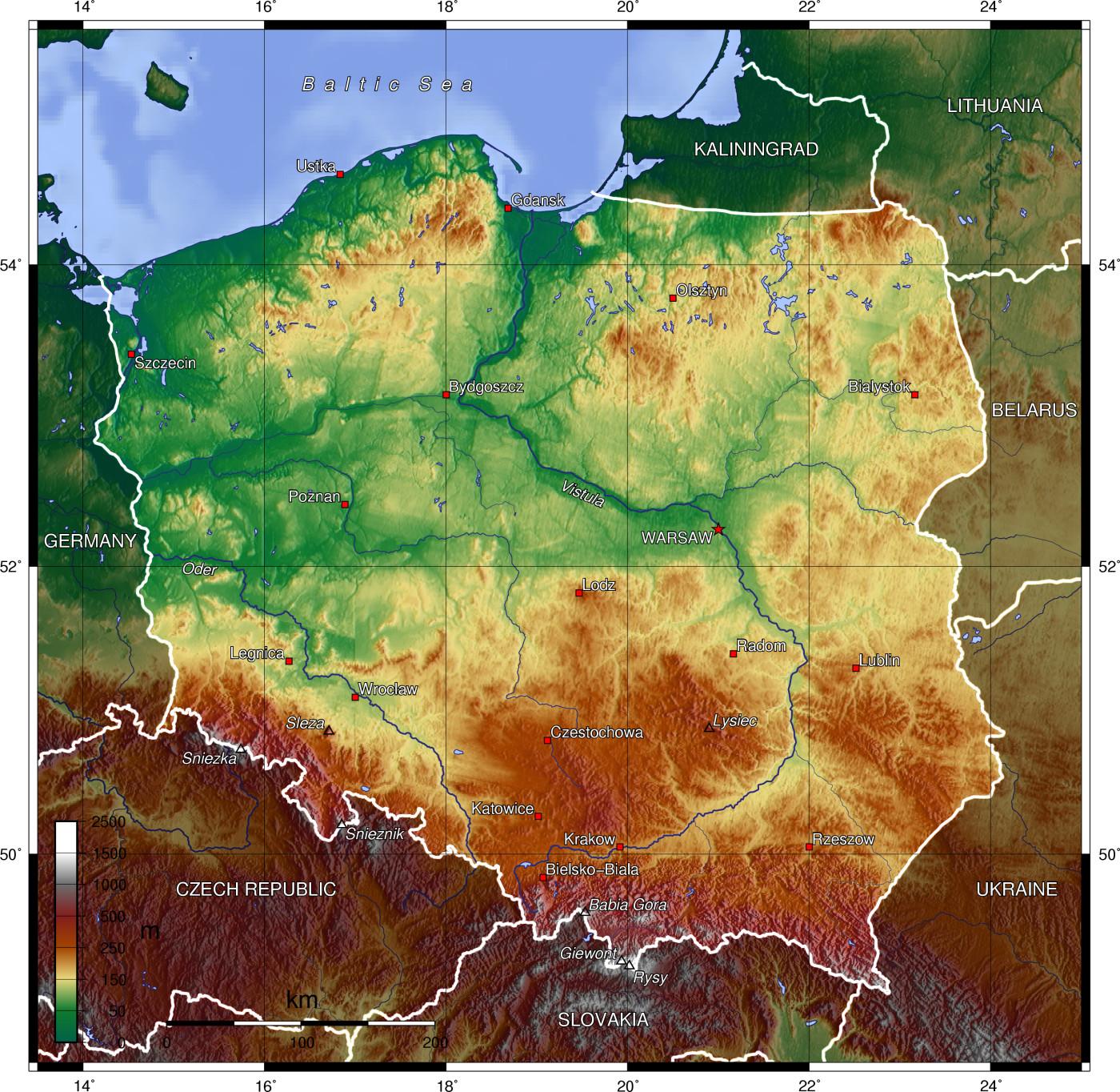
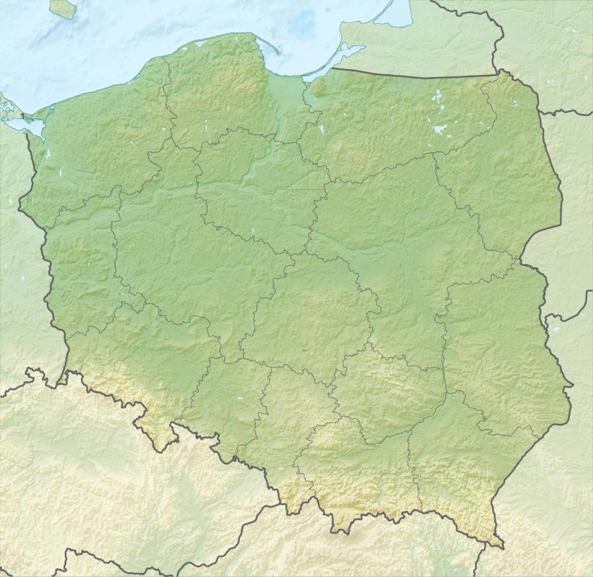
The Poland physical map shows landform and geography of Poland. This geographical map of Poland will allow you to discover physical features of Poland in Europe. The Poland physical map is downloadable in PDF, printable and free.
Poland territory extends across several geographical regions, between latitudes 49° and 55° N, and longitudes 14° and 25° E as its mentioned in Poland physical map. In the north-west is the Baltic seacoast, which extends from the Bay of Pomerania to the Gulf of Gdańsk. This coast is marked by several spits, coastal lakes (former bays that have been cut off from the sea), and dunes. The largely straight coastline is indented by the Szczecin Lagoon, the Bay of Puck, and the Vistula Lagoon. The centre and parts of the north lie within the North European Plain.
As seen on the physical map of Poland, the country has a coastline on the Baltic Sea to the north. The coastline is fairly smooth with beaches and sand dunes but indented by scattered low-rising cliffs. From the Baltic lowlands, Poland land rises gently into tree-covered hilly areas, with some higher elevations in the Pomeranian Lake District in the northeast. The northern regions are somewhat hilly. Flat fertile farmlands and river valleys dominate the Central Lowlands that blend into a hillier area to the south of the Vistula River. The southern third of the country is a mountainous region.
Poland relief structure can be divided more specifically into a series of east-west-trending zones as you can see in Poland physical map. To the north lie the swamps and dunes of the Baltic coast; south of these is a belt of morainic terrain with thousands of lakes, the southern boundary of which marks the limit of the last ice sheet. The third zone consists of the central lowlands, whose minimal relief was created by streams issuing from the retreating glaciers. This zone is the Polish heartland, the site of agriculture in places where loess has been deposited over the relatively infertile fluvioglacial deposits. The fourth zone is made up of the older mountains and highlands to the south; though limited in extent, it offers spectacular scenery. Along the southern border of the country are the Sudeten and Carpathian ranges and their foothills.
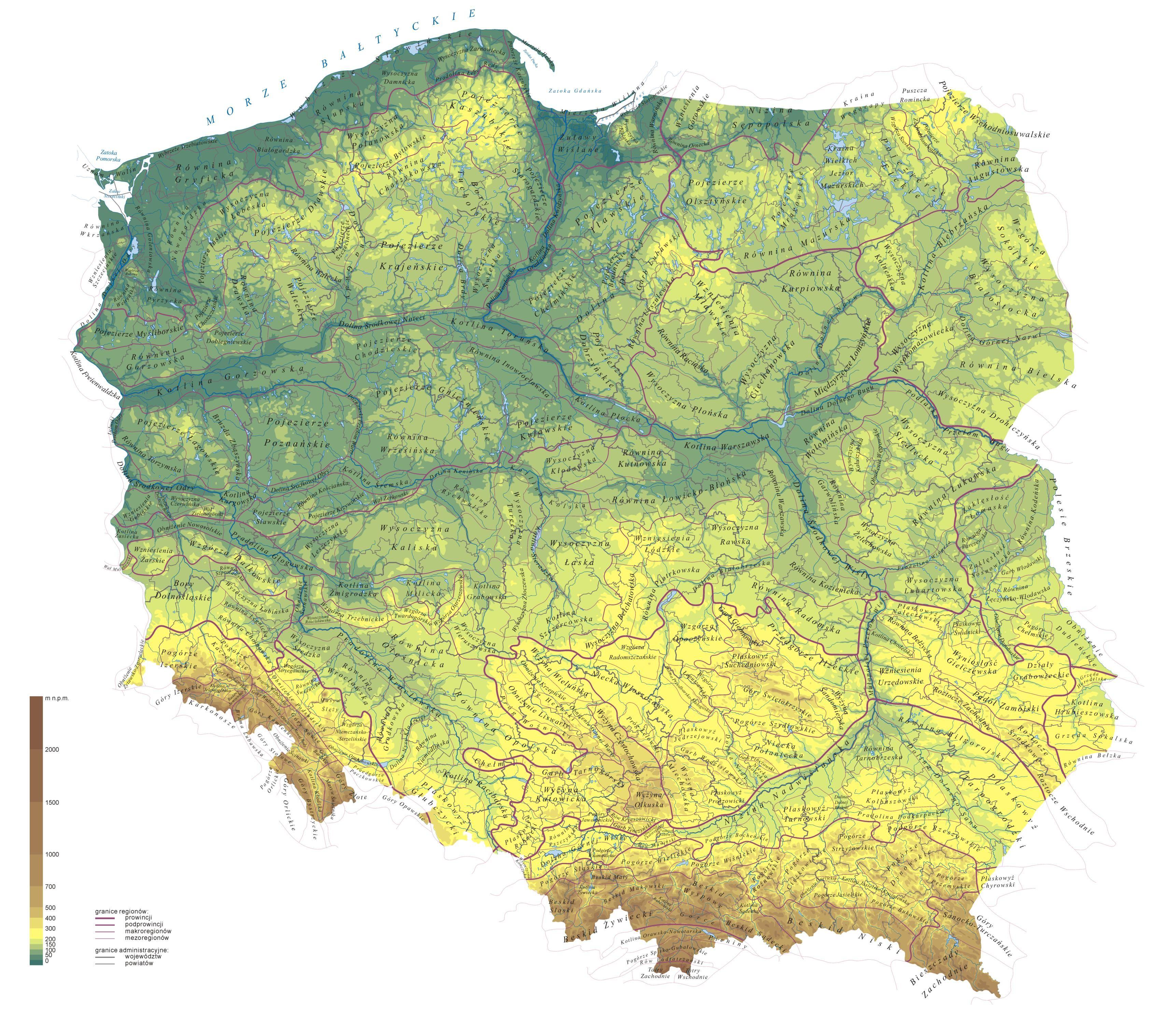
Poland topographic map shows the physical features of Poland. This topographical map of Poland will allow you to discover landforms and geographical of Poland in Europe. The Poland topographic map is downloadable in PDF, printable and free.
Poland as on topographic map extends 876 kilometers from north to south and 689 kilometers from east to west, at an area of 564,5897 square kilometers including inland waters. The average elevation is 173 meters, and only 3% of Polish territory, along the southern border, is higher than 500 meters. The highest elevation is Mount Rysy, which rises 2,499 meters in the Tatra Range of the Carpathians, 95 kilometers south of Kraków. About 60 square kilometers along the Gulf of Gdańsk are below sea level. Poland is traditionally divided into five topographic zones from north to south.
The largest, the central lowlands or "Polish Plain" (Polish: Niż Polski or Nizina Polska), is narrow in the west, then expands to the north and south as it extends eastward as its mentioned in Poland topographic map. Along the eastern border, this zone reaches from the far northeast to within 200 kilometers of the southern border. The terrain in the central lowlands is quite flat, and earlier glacial lakes have been filled by sediment. The region is cut by several major rivers, including the Oder (Odra), which defines the Silesian Lowlands in the southwest, and the Vistula (Wisla), which defines the lowland areas of east-central Poland.
To the south of the lowlands are the lesser Poland uplands, a belt varying in width from 90 to 200 kilometers, formed by the gently sloping foothills of the Sudeten and Carpathian mountain ranges and the uplands that connect the ranges in southcentral Poland as its shown in Poland topographic map. The topography of this region is divided transversely into higher and lower elevations, reflecting its underlying geological structure. In the western section, the Silesia-Kraków Upthrust contains rich coal deposits. The third topographic area is located on either side of Poland's southern border and is formed by the Sudeten and Carpathian ranges. Within Poland, neither of these ranges is forbidding enough to prevent substantial habitation; the Carpathians are especially densely populated. The rugged form of the Sudeten range derives from the geological shifts that formed the later Carpathian uplift.
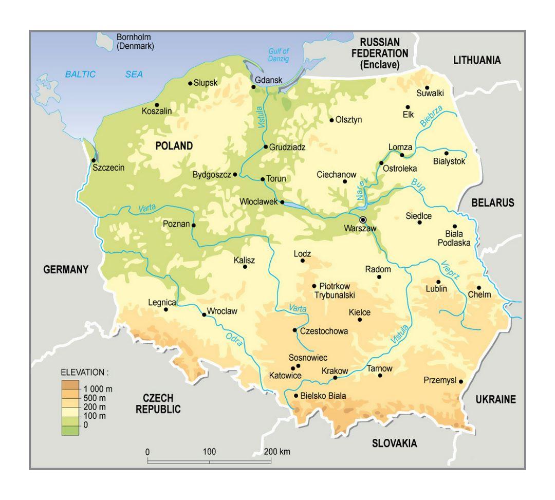
The Poland elevation map shows the different altitudes of Poland. This altitude map of Poland will allow you to know where are the highest and lowest regions of Poland in Europe. The Poland elevation map is downloadable in PDF, printable and free.
The natural landscape of Poland can be divided broadly into three relief groups: the lowlands, the highlands, and the mountains. The eastern extremes of Poland display characteristics common to eastern Europe, but the rest of the country is linked to western Europe by structure, climate, and the character of its vegetation. The lowland characteristics predominate: the average elevation of the whole country is only 568 feet (173 metres) above sea level, while more than three-fourths of the land lies below 650 feet as its shown in Poland elevation map.
The highest elevation in the Sudeten is Śnieżka (1,602 meters) in the Karkonosze Mountains as you can see in Poland elevation map. Sněžka (Czech), Śnieżka (Polish), or Schneekoppe (German) is the highest peak in the Krkonoše (also known as Karkonosze (Polish) or Riesengebirge (German) (literally Giant Mountains)), a part of the Sudetes mountain range. It rises to 1,602 metres (5,260 ft) above sea level. Since 1945, it lies on the Czech-Polish border, and a border stone is placed on the very top of the mountain. Sněžka is the highest point in the Czech Republic.
With a length of 651 miles (1,047 kilometres) and a drainage basin of some 75,100 square miles (194,500 square kilometres) as its shown in Poland elevation map, it is a waterway of great importance to the nations of eastern Europe; more than 85 percent of the river drainage basin, however, lies in Polish territory. The lowest point in Poland — at 2 metres (6.6 elevation ft) below sea level — is at Raczki Elbląskie, near Elbląg in the Vistula Delta.
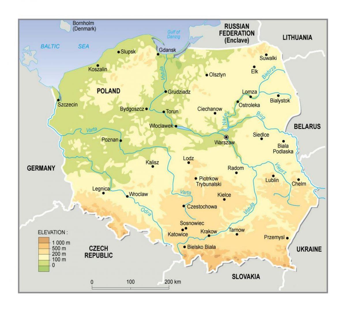
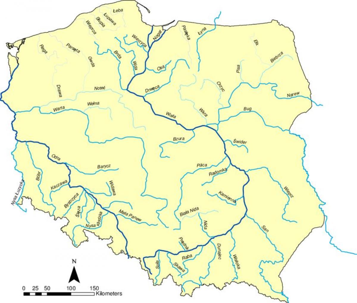
The rivers in Poland map shows the principal rivers with their names of Poland. The rivers map of Poland will allow you to find the main rivers which flow in and through Poland in Europe. The Poland rivers map is downloadable in PDF, printable and free.
The longest rivers are the Vistula (Polish: Wisła), 1,047 kilometres (651 mi) long; the Oder (Polish: Odra) which forms part of Poland’s western border, 854 kilometres (531 mi) long; its tributary, the Warta, 808 kilometres (502 mi) long; and the Bug, a tributary of the Vistula, 772 kilometres (480 mi) long as its mentioned in Poland rivers map. The Vistula and the Oder flow into the Baltic Sea, as do numerous smaller rivers in Pomerania.
The Łyna and the Angrapa flow by way of the Pregolya to the Baltic, and the Czarna Hańcza flows into the Baltic through the Neman. While the great majority of Poland rivers drain into the Baltic Sea, Poland Beskids are the source of some of the upper tributaries of the Orava, which flows via the Váh and the Danube to the Black Sea as you can see in Poland rivers map. The eastern Beskids are also the source of some streams that drain through the Dniester to the Black Sea.
Poland rivers have been used since early times for navigation (see Poland rivers map). The Vikings, for example, traveled up the Vistula and the Oder in their longships. In the Middle Ages and in early modern times, when the Polish–Lithuanian Commonwealth was the breadbasket of Europe; the shipment of grain and other agricultural products down the Vistula toward Gdańsk and onward to other parts of Europe took on great importance.
The mountains in Poland map shows the principal mountains with their names in Poland. The mountains map of Poland will allow you to find the main mountains ranges and highest mountains of Poland in Europe. The Poland mountains map is downloadable in PDF, printable and free.
Poland has 70 mountains over 2,000 metres (6,600 ft) in elevation, all in the Tatras as its mentioned in Poland mountains map. The Polish Tatras, which consist of the High Tatras and the Western Tatras, is the highest mountain group of Poland and of the entire Carpathian range. In the High Tatras lies Poland’s highest point, the north-western peak of Rysy, 2,499 metres (8,199 ft) in elevation. At its foot lies the mountain lakes Czarny Staw pod Rysami and Morskie Oko.
The second highest mountain group in Poland is the Beskids, whose highest peak is Babia Góra, at 1,725 metres (5,659 ft) as its mentioned in Poland mountains map. The next highest mountain group is the Karkonosze in the Sudetes, whose highest point is Śnieżka, at 1,602 metres (5,256 ft). Among the most beautiful mountains of Poland are the Bieszczady Mountains in the far southeast of Poland, whose highest point in Poland is Tarnica, with an elevation of 1,346 metres (4,416 ft).
Tourists frequent the Gorce Mountains in Gorce National Park, whose highest point is Turbacz, with elevations 1,310 metres (4,298 ft), and the Pieniny in Pieniny National Park, whose highest point is Wysokie Skałki (Wysoka), with elevations 1,050 metres (3,445 ft) as you can see in Poland mountains map.
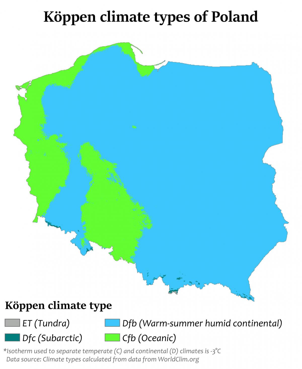
The Poland climate map shows average temperature and climate zones of Poland. This climate map of Poland will allow you to know weather, average precipitation, average sunshine and different climates of Poland in Europe. The Poland climate map is downloadable in PDF, printable and free.
The climate is mostly temperate throughout Poland. The climate is oceanic in the north and west and becomes gradually warmer and continental towards the south and east. Summers are generally warm, with average temperatures between 18 °C (64 °F) and 30 °C (86.0 °F) depending on a region as its shown in Poland climate map. Winters are rather cold, with average temperatures around 3 °C (37.4 °F) in the northwest and −6 °C (21 °F) in the northeast. Precipitation falls throughout the year, although, especially in the east; winter is drier than summer.
The warmest region in Poland is Lower Silesian located in south-western Poland where temperatures in the summer average between 24 °C (75.2 °F) and 32 °C (90 °F) but can go as high as 34 °C (93.2 °F) to 39 °C (102.2 °F) on some days in the warmest month of July and August as you can see in Poland climate map. The warmest cities in Poland are Tarnów, which is situated in Lesser Poland and Wrocław, which is located in Lower Silesian.
The average temperatures in Wrocław being 20 °C (68 °F) in the summer and 0 °C (32.0 °F) in the winter, but Tarnów has the longest summer in whole Poland, which lasts for 115 days, from mid-May to mid-September as its shown in Poland climate map. The coldest region of Poland is in the northeast in the Podlaskie Voivodeship near the border of Belarus. Usually the coldest city is Suwałki. The climate is affected by cold fronts which come from Scandinavia and Siberia. The average temperature in the winter in Podlaskie ranges from −6 °C (21 °F) to −4 °C (25 °F).


